Åkersberga
Åkersberga | |
|---|---|
 Åker's Canal in Åkersberga | |
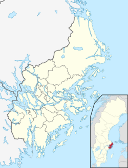
| Coordinates: 59°29′N 18°18′E / 59.483°N 18.300°E | |
| Country | Sweden |
| Province | Uppland |
| County | Stockholm County |
| Municipality | Österåker Municipality |
| Area | |
• Total | 16.27 km2 (6.28 sq mi) |
| Population (31 December 2020)[2] | |
• Total | 35,747 |
| • Density | 2,200/km2 (5,700/sq mi) |
| Time zone | UTC+1 (CET) |
| • Summer (DST) | UTC+2 (CEST) |
Åkersberga is a locality and the seat of Österåker Municipality, Stockholm County, Sweden with 28,033 inhabitants in 2010.[1]
History
[edit]In 1901 a railway station named Berga was opened on this rural spot some 30 km from Stockholm. Some shops and a post office followed. The name Berga was changed to Åkers Berga to avoid confusion with other places in Sweden named Berga, and the present name evolved from this. After World War II the village grew and blocks of flats were built. Åkersberga gradually evolved into a suburb with many of its inhabitants commuting to work-places in Stockholm, and has become more urban in character.
Between 1974 and 1982 Åkersberga was the seat of Vaxholm Municipality. When the municipality was split in 1983, Åkersberga became the seat of the reinstituted Österåker Municipality.
Notable people from Åkersberga include Loreen, Jesper Parnevik, Alexander Östlund and Richard S. Johnson. The punk rock band Coca Carola is from Åkersberga, as are the bands Lustans Lakejer and Eskobar, of which the former have released an album named Åkersberga.
Åkersberga is served by the narrow-gauge urban railway Roslagsbanan, which has four stops in the town, Österskär, Tunagård, Åkersberga Station and Åkers Runö.
Sports
[edit]The following sports clubs are located in Åkersberga:
People from Åkersberga
[edit]- Tommy Albelin, ice hockey player
- Carina Berg, TV-host
- Andreas Lennkvist Manriquez, former MOP
- Ingrid Carlberg, author
- Mattias Gustafsson, handboll player
- Richard S. Johnson, golf player
- Johan Kinde, musician
- Thomas Lagerlöf, football trainer
- Loreen, singer
- Pär Nuder, former minister of finance
- Jesper Parnevik, golf player
- Patrik Peter, journalist
- Ola Skinnarmo, adventurer
References
[edit]- ^ a b "Tätorternas landareal, folkmängd och invånare per km2 2005 och 2010" (in Swedish). Statistics Sweden. 14 December 2011. Archived from the original on 27 January 2012. Retrieved 10 January 2012.
- ^ "Statistiska tätorter 2020, befolkning, landareal, befolkningstäthet". Statistics Sweden. 31 December 2020. Retrieved 2 June 2024.
External links
[edit] Media related to Åkersberga at Wikimedia Commons


